Home Multi-Country Search About Admin Login
Cenozoic
Cretaceous
Jurassic
Triassic
Permian
Carboniferous
Devonian
Early Paleozoic

Search by
Select Region(s) to search
Hold Ctrl (Windows/Linux) or Command (Mac) to select multiple
Pa Kae Formation
Click to display on map of the Ancient World at:
Pa Kae Fm base reconstruction

Pa Kae Fm


Period: 
Ordovician

Age Interval: 
Upper Ordovician (Caradoc to Lower Ashgill) (3)


Province: 
Sibumasu: Lower Peninsula

Type Locality and Naming

Named after Pa Kae village where type section located, to the north of Langu district, Satun province by Wongwanich et al. (1990),

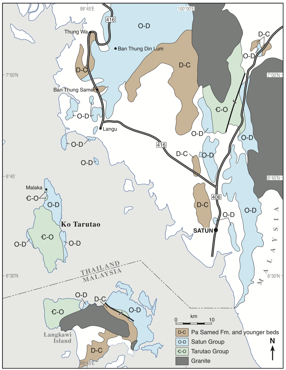
[Figure: Sketch geological map (from various sources) of the southern part of Peninsular Thailand and Langkawi Island of Malaysia. Note that Thai stratigraphic nomenclature has been extended to Langkawi Island (Ridd. 2011)]

Synonym: หมวดหินป่าแก


Lithology and Thickness

The lower part, 34 m thick, limestone, red, poorly laminated to very thin bedded; with darker red argillaceous partings, and abundant crinoids debris, stromatolitic polygons. The upper part, 32 m thick, dominated by nodular limestone.
Parent unit: Top-most unit of the Thung Song Gr (Wongwanich and others, 1990), but Ridd (2011) also assigned it to the Satun Gr.
Thickness: 66 m at the type section, 126 m thick at Petra National Park

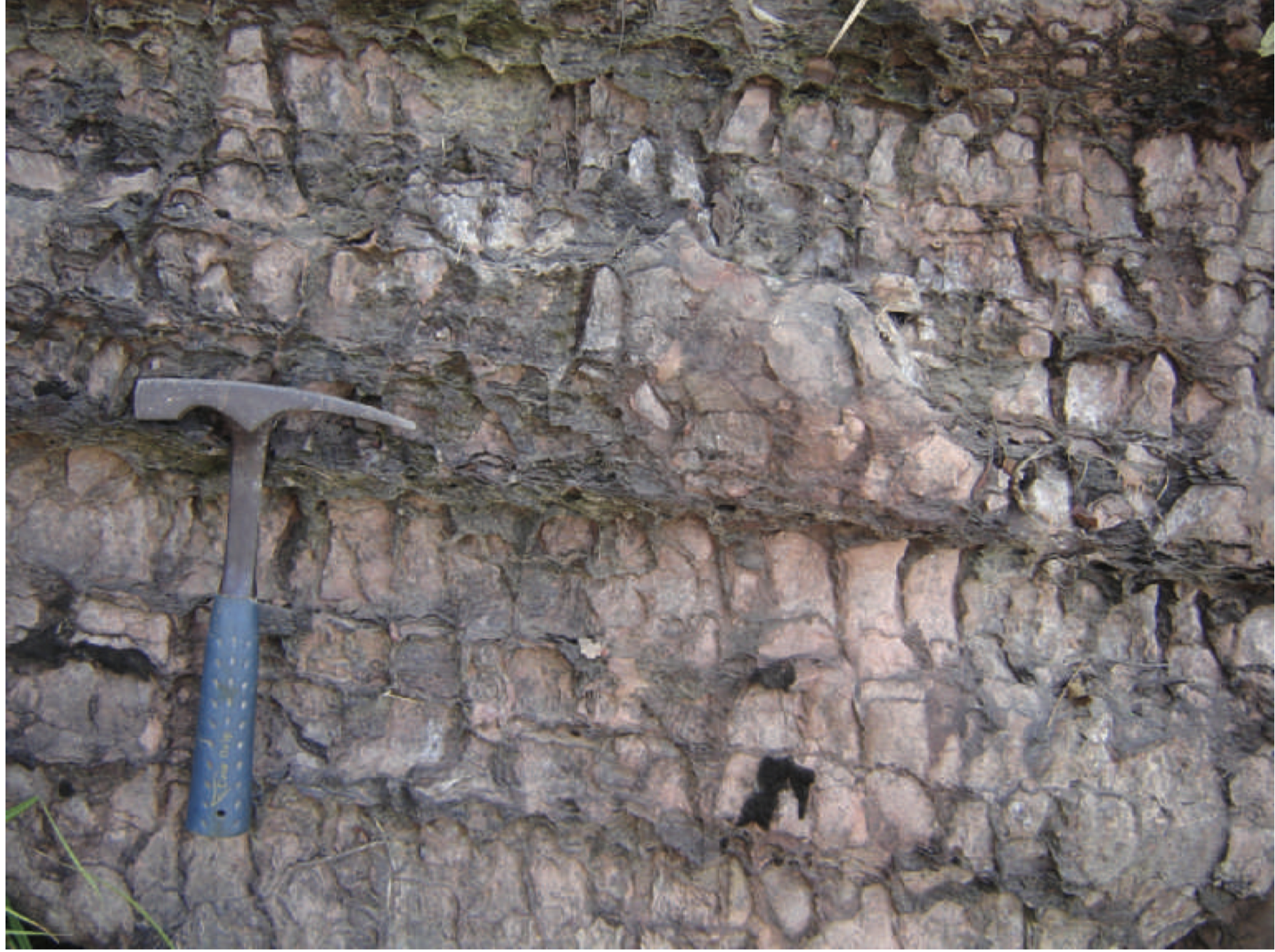
[Figure1: Upper Ordovician Pa Kae Formation; pale pink to grey limestone dipping gently to the right, with characteristic network of non-calcareous mineral, possibly caused by clay-filled pressure-solution cracks. East of Langu-Thung Wa road at about 6858 0 34 00 N, 99846 0 28 00 E (Ridd, 2011).]

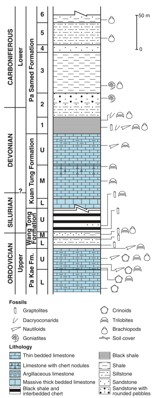
[Figure2: Composite stratigraphic section of the Upper Ordovician to Carboniferous near Ban Thung Samet, between Km 10 and Km 11 on the Langu to Thung Wa road in Satun Province. From Ridd (2011), which is modified after Wongwanich et al. 2002).]


Lithology Pattern: 
Limestone


Relationships and Distribution

Lower contact

Thung Song Limstone Fm (conformable)

Upper contact

Wang Tong Fm at base of Thong Pha Plum Gr (conformable)

Regional extent

Lower Peninsula: Satun province


GeoJSON

{"type":"Feature","geometry":{"type":"MultiPolygon","coordinates":[[[[99.37,9.2],[99.66,9.37],[99.89,9.32],[100.16,8.78],[100.39,7.93],[100.58,6.98],[100.57,6.39],[100.32,6.3],[99.81,6.7],[99.24,7.45],[98.82,8.18],[99.08,8.51],[99.37,9.2]]]]}}

Fossils

The Pa Kae Fm has an abundant trilobite fauna which was the subject of an important study by Fortey (1997). He described 39 species and found very close similarities to the Pagoda Formation of southern China, stating ‘. . . the extraordinary similarity of the Thai fauna to those of the Yangtze Platform is beyond question, and might favor geographical proximity over the distributive effects of ocean currents.’ It is an outer-shelf assemblage dominated by nileids, Ovalocephalus and remopleuridids.


Age 

On the basis of its trilobites, orthoconic nautiloids, gastropods, crinoids, brachiopods and ostracods, the Pa Kae Fm was considered by Cocks et al. (2005) to be of latest Caradoc to early Ashgill age. Conodonts studied by Agematsu et al. (2007) indicated a Darriwilian (mid-Ordovician) to Late Ordovician age (Ridd, 2011, p.8-9; used here).

Age Span: 

    Beginning stage: 
Darriwilian

    Fraction up in beginning stage: 
0.5

    Beginning date (Ma): 
462.81

    Ending stage: 
Katian

    Fraction up in the ending stage: 
1.0

    Ending date (Ma):  
445.16

Depositional setting

Low-energy continental slope or deeper water (Agematsu et al., 2007)


Depositional pattern:  


Additional Information


Compiler:  
Wen Du - modified from Ridd. M. F., 2011, Chapter 3 Lower Palaeozoic in: Ridd, M.F., Barber, A.J., and Grow, M.J., editors, The Geology of Thailand, Geol. Soc. of London.
Lexicon of Stratigraphic Names of Thailand of 2013.